
The Exact Address, and Why Thirumalashettyhalli Has Three Spellings
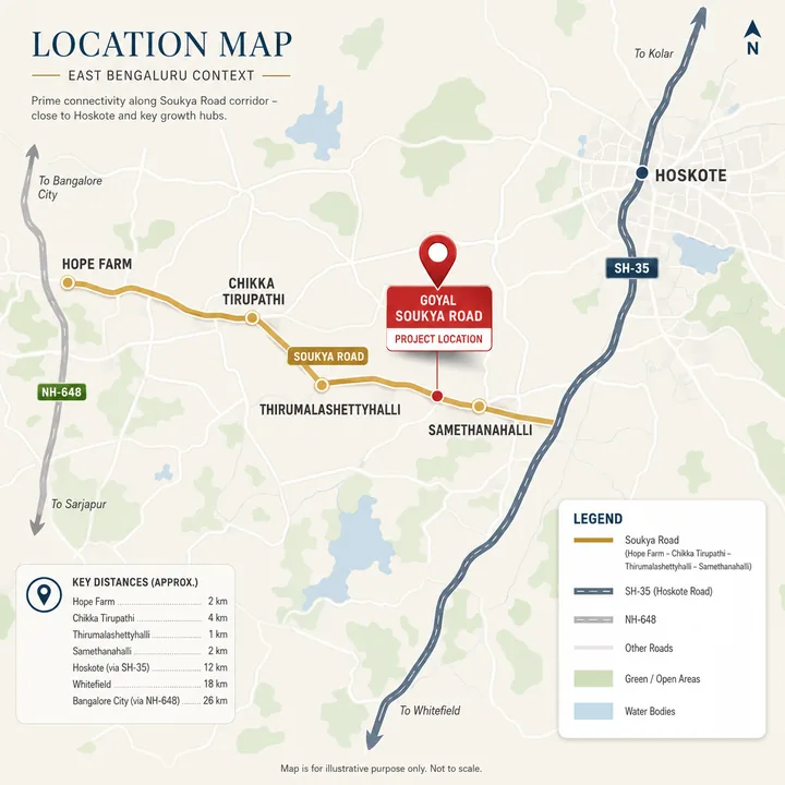
The parcel described in circulation sits in the Thirumalashettyhalli–Samethanahalli stretch, roughly the first third of Soukya Road east of the Whitefield edge. Both villages are in Hoskote taluk, Bengaluru Rural, and both return PIN 560067. The village name is genuinely unstable across sources — a fact to state, not a typo to tidy away:
| Spelling | Where it is authoritative |
|---|---|
| Thirumalashettyhalli | The form Google's query suggestions carry; the primary on-page spelling here |
| Thirumalashettyhally | The form the portals index — Square Yards and Dwello both carry locality pages under it |
| Thirumalashettihalli | The OpenStreetMap and Nominatim form, so the one that belongs in a structured address field |
All three name the same revenue village, and this site uses all three on purpose — expect the transliteration to vary between a khata extract, a sale deed and a survey record for the same land.
Pin codes: three are in circulation on one corridor. The Thirumalashettyhalli pin code and the Samethanahalli pin code are both 560067; Hoskote town is 562114; Kannamangala, 5 km north on a different road, is 560115. Marketing copy for this belt also circulates Whitefield's 560066. Take the PIN from the khata, not from a brochure.
The published pin is a village node, not a site boundary. The coordinates used across this site, 12.98484 N, 77.78384 E, are the OpenStreetMap node for Thirumalashettihalli village. No survey number and no plan drawing has been obtained, so read every map here as corridor-representative, not as a project gate. The nearest verifiable built structure to that node is Birla Alokya, at 12.98890 N, 77.78913 E, tagged to the same village. A search for Samethanahalli apartments for sale, or flats for sale under any of these village names, covers a catchment about two kilometres wide indexed under four labels.
Jurisdiction: Hoskote Taluk, Bengaluru Rural, and a BMRDA Planning Authority
This is the most consequential fact on the page, and almost no competing page states it. These parcels are not under BBMP and not under the BDA. They fall in Hoskote taluk, Bengaluru Rural, under the Hoskote Planning Authority — one of twelve Local Planning Authorities listed on BMRDA's own Local Planning Areas page, office on Mission Hospital Road, Hoskote 562114. Plan sanction, layout approval and the khata regime run through it. The boundary physically crosses this corridor: five kilometres west, Kadugodi resolves to Bengaluru East City Corporation, created under the Greater Bengaluru governance structure in September 2025. One road, two sanctioning regimes, two water utilities, two property-tax regimes.
There is direct registry evidence for where the line falls. Provident Botanico, further east on this road, was acknowledged under Karnataka RERA code 1251/446 (Bengaluru East, Urban) but registered under 1250/304 (Bengaluru Rural, Hoskote taluk); barely 0.6% of registrations show any such mismatch. That taluk code is carried by every registered project on this stretch — Birla Alokya, Provident Botanico, Sobha OneWorld and Goyal's own Riviera Uno. Any future registration here should carry it too, in the form PRM/KA/RERA/.../PR/.... There is none today.
What "BMRDA approved" does and does not mean. A Local Planning Authority sanction is a valid approval route, but it is not the same regime as a BDA sanction, and treating them as interchangeable is an expensive mistake here. Three questions settle it: which authority issued the sanctioned plan, by name, on the drawing; what khata class the land carries, and whether an e-khata has been generated for Hoskote taluk property, a different queue from BBMP's; and whether the DC land-conversion order exists.
Soukya Road Runs East, Not North — the Geometry Most Pages Get Wrong
Soukya Road is the Hope Farm to Chikka Tirupathi axis, running east–west. It is not the Whitefield–Hoskote road; that is SH-35, a separate corridor running north from the same junction through Kadugodi and Belathur. The two share one junction and nothing else, and confusing them corrupts every distance downstream. The named way in OpenStreetMap runs from 12.98792, 77.78199 east to 12.98270, 77.82838 — about 5 km, tagged secondary — and its western continuation is separately named Channasandra Main Road. A BMTC stop at that western end is signed "Hope Farm (Towards Chikka Thirupathi)". By road it is 9.7 km from the junction to the eastern end of the named stretch and 20.1 km on to Chikkatirupathi, which is in Malur taluk, Kolar district. The junction to Hoskote town, along SH-35, is 14.0 km.
| Village, west to east | Coordinates |
|---|---|
| Channasandra | 12.98049, 77.76839 |
| Thirumalashettyhalli | 12.98484, 77.78384 |
| Koralur | 12.99732, 77.78445 |
| Samethanahalli | 12.97936, 77.79073 |
| Bodana Hosahalli | 12.97842, 77.80196 |
| Kacharakanahalli | 12.99576, 77.81457 |
| Dodda Dunnasandra | 12.97727, 77.81612 |
| Bisanahalli | 12.99316, 77.82278 |
One entry in that table needs a caveat, and it is the one the price portals disagree about. The list is ordered by longitude, west to east, but Koralur is not on Soukya Road. Its node sits 1.38 km almost due north of the Thirumalashettyhalli node — 1.9 km by road — and 2.1 km from Samethanahalli in a straight line, 2.8 km by road. It shares the taluk and the PIN, not the frontage. That matters on the price page, where Koralur's published rate is 51% below Samethanahalli's; the two villages are further apart, and less similarly served, than a longitude-ordered list makes them look.
Two other names commonly attached to this road do not belong to it either: Kannamangala is 5 km north on SH-35, Doddabanahalli 5 km north-west. A distance quoted from either will not reproduce from here.
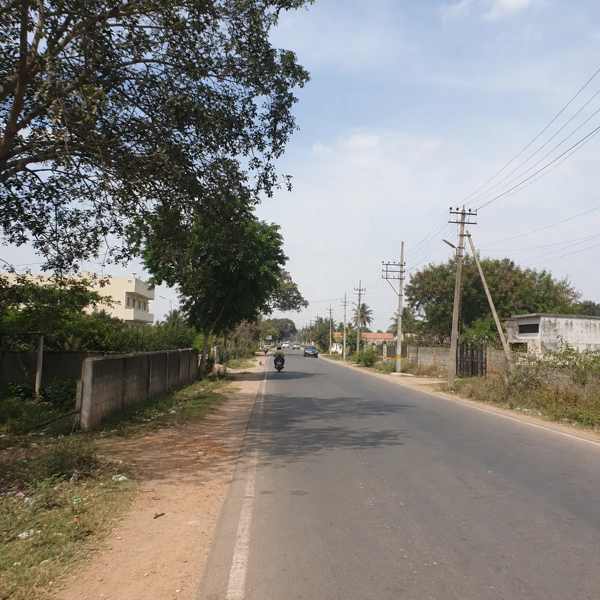
An honest note on the road itself. Soukya Road is tagged secondary with no lane count recorded — a two-lane village arterial now carrying township traffic. A reported drains-footpaths-lighting upgrade exists for SH-35 to the north, but it is sourced only through secondary pages. No funded widening scheme for Soukya Road itself was located. Drive it at 9 am on a weekday rather than reading a figure.
The Nearest Metro Station to Soukya Road, Measured by Road
This is where nearly every published page on this corridor gets the answer backwards.
| Purple Line station | By road | Straight line | Detour factor |
|---|---|---|---|
| Kadugodi Tree Park | 5.1 km | — | 1.12 |
| Hopefarm Channasandra | 5.3 km | — | — |
| Whitefield (Kadugodi) terminus | 6.4 km | 3.5 km | 1.84 |
Only the terminus's straight-line figure and two detour factors were captured in the source routing; the rest are left blank rather than back-calculated. The terminus is the closest station as the crow flies, at 3.5 km, and the farthest of the three by road, at 6.4 km. A detour factor of 1.84 against 1.12 is what a limited-crossing arterial does to a map: the straight line crosses land the road network does not follow, so you drive west, then north, then back east. Publish the straight-line answer and the station ranking inverts on the ground, with a commute a quarter longer than advertised.
The same answer covers the Samethanahalli nearest metro station question: add about 0.8 km to each figure and the ordering is unchanged. The last leg is a drive, not a walk — there is no Purple Line station on Soukya Road and none is proposed.
Soukya Road to Whitefield and ITPL: the Road Distances
These are free-flow driving distances routed on the OpenStreetMap network — road distances, not crow-fly, and without East Bengaluru's peak multiplier. The routing origin is stated exactly, because it is not the village pin. The distances below are routed from the Birla Alokya node at 12.98890 N, 77.78913 E — the nearest mapped built structure on this belt, and the only point here a router can snap reliably to Soukya Road itself. It sits about 1.2 km east-north-east of the Thirumalashettyhalli village node we publish on every map.
That gap is small but not nothing, and it runs in one direction: from the village node the same targets read slightly shorter westward and slightly longer eastward. Hope Farm junction, for instance, is 4.5 km from the Birla Alokya origin and 3.8 km from the village node. Treat every figure in this table as a belt distance accurate to a few hundred metres, not as a gate-to-gate measurement — there is no gate, because there is no surveyed boundary for this parcel.
| Destination | Road distance | What it is |
|---|---|---|
| Hope Farm junction | 4.5 km | The western gateway to the corridor |
| Whitefield railway station | 4.9 km | Suburban rail, Bangalore–Bangarpet line |
| Nearest Purple Line station | 5.1 km | See the metro table above |
| ITPL | 6.9 km | The primary employment anchor |
| Hoskote town | 11.6 km | Taluk headquarters; jurisdictional, not a daily trip |
| KR Puram railway station | 16.9 km | Main-line rail and the Outer Ring Road interchange |
| Kempegowda International Airport | 43.5 km | About 41 minutes free-flow |
The airport figure needs a caveat rather than a highlight: 41 minutes is what an empty road produces at 3 am. Plan 60 to 90 minutes for a flight; a single airport number for East Bengaluru without that qualification quotes a routing engine, not a journey. And the Soukya Road to Whitefield distance has no single answer, because Whitefield is an area rather than a point — railway station 4.9 km, ITPL 6.9 km, the retail spine between them. All of it is reached through one junction 4.5 km west, and the corridor's traffic reality is a function of that junction more than of the distance.
NH-648 (STRR) Runs 0.78 km Away — and the Segment Past This Belt Was Not Open
On paper this is the corridor's largest structural advantage, and it is routinely understated. Measured on the highways' own geometry, the straight-line distances from this belt are NH-648, the Satellite Town Ring Road, at 0.78 km; SH-35 at 3.43 km; and NH-75, Old Madras Road, at 7.61 km. Those are straight-line and labelled as such — the actual access point is further, because you reach it over the local road network. Even so, one widely circulated claim puts the STRR entry at 6 to 8 km from this belt, roughly an order of magnitude wrong.
The caveat is larger than the advantage. The 80 km Dabaspete–Hoskote section was inaugurated on 11 March 2024 and is open. The section that actually runs past Soukya Road — Hoskote to the Tamil Nadu border — was not open in the most recent reporting we could verify: 20.25 km of 20.9 km complete, blocked by a gap of roughly 650 m at a rail overbridge, targeted for June 2026 after a slip of about sixteen months.
That is a dated, checkable status, not an open-ended promise, and it is the fact on this corridor most likely to have moved — check it on the day you visit. When the gap closes, the belt gains a grade-separated route south towards Hosur and a northern alternative to the airport that avoids the city. Until it does, the highway is a line on a map 780 m away that you cannot get onto in the direction that matters.
Employment: One Anchor, One Junction
The employment case for this address is Whitefield's, and it runs through a single funnel. ITPL at 6.9 km by road is the anchor, with the wider EPIP and Whitefield technology cluster around it — genuinely short by Bengaluru standards. But all of it routes through Hope Farm junction and the Whitefield Main Road spine, so the corridor inherits Whitefield's congestion in full without being inside it.
Hoskote's KIADB industrial area, 11.6 km by road, is the secondary story — a real industrial base, described in industrial-land material as a red-zone estate hosting chemicals, polymers, steel-rolling and pharmaceutical units. That classification could not be confirmed against a Karnataka State Pollution Control Board record, and no KSPCB consent or violation record was located for any unit within 5 km of these parcels, so direct industrial adjacency is not established, nor ruled out. Otherwise the corridor's commercial base is thin: there is no office park on Soukya Road.
The honest read is a residential belt attached to one employment district by one road: good if you work in Whitefield, poor if you work in north or south Bengaluru.
Social Infrastructure: What Is on the Road, and What Is a Drive Away
One institution here is verified in detail, because the road is named after it. SOUKYA — Dr Mathai's International Holistic Health Centre occupies roughly 30 acres at Samethanahalli, mapped at 12.99617, 77.79778. Measured against the village node this site publishes, 12.98484, 77.78384, that is 1.97 km in a straight line and 3.5 km by road — the campus sits north of Soukya Road, so the road route is nearly double the crow-fly figure. (From the Birla Alokya reference point further east it is about 1.2 km straight-line, which is where the "about a kilometre" figure in circulation comes from; it is not the distance from the pin on our map.) Be precise about what the campus means for a resident: it is a residential wellness and integrative-medicine campus, not an emergency hospital, and it does not answer the question "where is the nearest casualty department".
Beyond it, this belt's schools, hospitals and retail are Whitefield's, reached through the same 4.5 km western funnel. That cluster is deep and long-established: on healthcare, the Vydehi Institute of Medical Sciences near EPIP, Manipal Hospital Whitefield, the Sathya Sai Institute of Higher Medical Sciences and Cloudnine's Whitefield unit; on schooling, Deens Academy, Vydehi School of Excellence, Whitefield Global School, VIBGYOR High Whitefield and National Public School Whitefield; on retail, Park Square Mall inside ITPL, VR Bengaluru and Nexus Shantiniketan on Whitefield Main Road.
A necessary caveat on that list. Institution-level road distances were not independently routed in this pass, and the list is representative rather than exhaustive. Treat it as "the Whitefield cluster, reached through one junction at 4.5 km, plus the onward leg", and route the school or hospital you actually care about yourself. A fabricated two-decimal distance against each name would look more authoritative and be worth less.
On the corridor itself, expect village-scale amenities — local clinics, provision stores, a few standalone schools — which will thicken as the registered projects deliver, not before. One green anchor is often mis-attributed to this road: the Atal Bihari Vajpayee Botanical Garden, around 67 acres at 13.02945, 77.75672, is 10.5 km by road, on the SH-35 corridor to the north.
Water, Drainage and Flooding — the Corridor's Real Weak Point
Cauvery water does not reach here, and the reason is jurisdictional rather than technical. Cauvery Stage V added 775 MLD for the "110 villages" brought into BBMP. These parcels are in Hoskote taluk, outside BBMP entirely, so the scheme's boundary does not extend to Thirumalashettihalli, Samethanahalli or Koralur. This is not a timing question that resolves in a few years; it is a boundary question that resolves only if the boundary moves.
Even inside the scheme, delivery is incomplete. By mid-2026 BWSSB had roughly 89,000 connections and 104 of the 110 villages receiving water, with about 600 m of a 110.6 km trunk main still unlaid and the Kadugodi ground-level reservoir delayed by land acquisition. If the scheme's own beneficiary villages are still waiting, a village outside it should plan on nothing.
Borewell supply with tanker top-up is the realistic base case. Three questions are therefore non-optional: the borewell yield test — flow rate, at what depth, tested when and by whom; the sanctioned water source in writing, on the approval rather than in a sales conversation; and the STP and recharge design, which here is a supply measure, not a green badge.
Flooding is a live, recent and specific risk on the access route. Bengaluru's flash floods on 22 May 2026 hit Whitefield among the worst-affected areas, with the Whitefield–Hoskote arterial waterlogged; a separate IMD yellow-alert event on 19 May 2026 flooded Whitefield again. Reporting and residents attribute the repeat pattern to choked and encroached rajakaluves. Those events were concentrated on the Whitefield side rather than this stretch — but the Whitefield side is the route to work, school and hospital from here. Ask where the nearest rajakaluve runs relative to the parcel boundary, and for the site contour and storm-water discharge point on the sanctioned plan. A dry-season visit tells you nothing about this.
The Registered Neighbours, and What They Say About the Address
The most useful thing about this address is that it has real, registered, checkable neighbours — each quoted below with its correct holder, which matters more than it sounds.
| Project | Scale | K-RERA registration | Status |
|---|---|---|---|
| Birla Alokya, Soukya Road, Whitefield (Birla Estates) | 7.9 acres, 218 villaments, "Rs 2.15 Cr* onwards" | PRM/KA/RERA/1250/304/PR/190724/002725 | Ready-to-move; possession began Aug 2023 |
| Provident Botanico (Provident Housing, Puravankara) | 17 acres, 1,275 apartments, 9 towers | PRM/KA/RERA/1250/304/PR/210324/006726 | Possession stated from Dec 2028 |
| Riviera Uno, Soukya Road (marketed by Goyal & Co | Hariyana Group) | 12.36 acres, four-bedroom villas | PRM/KA/RERA/1250/304/PR/060225/007489, 6 Feb 2025 | Promoter of record: NIRVANA DEVELOPERS |
Birla Alokya is the anchor landmark and it is finished stock — any page presenting it as a live launch is out of date. Birla Estates' own wording is "Near Hope Farm Junction, Whitefield"; the developer does not itself lead with Soukya Road. Provident Botanico, mapped at 12.99055, 77.80621, is 2.5 km east in a straight line and about 3.7 km by road from the village node this site publishes — 2.3 km by road if you start from the Birla Alokya reference point, which is the figure most corridor copy quotes without saying where it started. Either way it proves a large apartment format works on this stretch.
Riviera Uno carries the trap worth knowing. Its promoter string holds no Goyal or Hariyana token, and no project name anywhere in the 9,880-row Karnataka registry contains the word "Goyal" — the brand prefix is a marketing convention. Search by brand and you will wrongly conclude the developer has no footprint here; search by project name and promoter. Three further names circulate in township copy for this road — "Royale Ville", "Riviera Apartments" and "Orchid Soukya Road" — none on the developer's own site or in the registry. Registrations under the Hoskote taluk code have run 29, 26, 27, 41 and 34 across 2022 to July 2026: supply is accelerating.
What to Weigh Before You Decide on This Address
Seven things count genuinely against this location. None is a reason not to buy; each is a reason to check harder and price differently.
- Water is not municipal, and no announced scheme changes that. Borewell and tanker is the base case unless a civic boundary moves.
- The route to work floods. You are not buying into the flood zone, but into the catchment that drives through it.
- The highway advantage is contingent on 650 metres of unfinished road. NH-648 at 0.78 km is a rare position — but only once the Hoskote-to-border section opens. Price what is open; treat the rest as upside.
- Everything routes through one junction. Hope Farm is the single point of failure for commuting, retail, schooling and healthcare.
- Price discovery is weak and the portals contradict each other. The Soukya Road locality average rests on about 6 projects and 167 listings; Koralur reads 51% below Samethanahalli, two villages 2.1 km apart in a straight line and 2.8 km by road; and every locality in the catchment reports an identical 3.9% rental yield — a constant, not data.
- The jurisdiction is more complex than a city address. Three PINs across one corridor, two civic regimes along one road, a planning authority most buyers have never dealt with, an e-khata queue that is not BBMP's.
- Local demand is villa-led, not apartment-led. The corridor's demand panel runs roughly 63% villa against 6% apartment demand, on a near-even supply split. That may invert as the large apartment projects deliver, but it is today's position and it matters for resale timing.
Against those sit four real strengths: 6.9 km by road to ITPL, three metro stations inside 5 to 6.5 km, a national-highway alignment under a kilometre away, and — unusually for a pre-launch address — three registered projects within about two kilometres whose prices and possession dates you can verify yourself in ten minutes.
What to Verify About This Location Before You Pay Anything
- The parcel. Survey numbers and the sanctioned plan drawing, and which authority issued it, by name. The pin on this site is a village node at Thirumalashettyhally, not a boundary.
- The registration. Search rera.karnataka.gov.in yourself. Goyal Soukya Road is not registered — not pending, not applied for, absent — and until a project-class number is issued, no booking amount, allotment letter or agreement to sell can lawfully be executed.
- The highway. Whether the Hoskote-to-Tamil-Nadu-border section of NH-648 has opened. It sits under a kilometre away and changes the corridor's arithmetic in both directions.
- The water and the drainage. Borewell yield test, sanctioned source in writing, STP and recharge design; then the nearest rajakaluve, site contour and storm-water discharge point. Do not accept "Cauvery is coming".
- The commute you will actually drive. Route your own office, school and hospital at 9 am on a weekday, from the site gate rather than a village node.
Every corridor figure above comes from mapped road geometry, official planning and registry records, developer-primary pages or dated news reporting. Every figure describing the Goyal project itself is attributed to the pre-launch information in circulation. When a sanctioned plan and a registration number exist, this page will be rewritten against them.
Enquire about Goyal Soukya Road
Register a non-binding interest and we will send you the survey numbers, the sanctioned layout, the Hoskote Planning Authority sanction letter and the Karnataka RERA certificate as each one appears. Until they do, we will say so plainly rather than fill the gap with a brochure figure.
Register Your InterestGoyal Soukya Road Location – Frequently Asked Questions
Which metro station is nearest to Soukya Road - and nearest by road?
By road the Purple Line ranks Kadugodi Tree Park at about 5.1 km, Hopefarm Channasandra at 5.3 km and the Whitefield (Kadugodi) terminus at 6.4 km. Almost every page written about this corridor names the terminus, because it is the nearest in a straight line at 3.5 km — but it carries a road-to-crow-fly detour factor of 1.84 against 1.12 for Kadugodi Tree Park, which is exactly how the ranking inverts. The same answer holds for the Samethanahalli nearest metro station question, since the two villages are barely a kilometre apart. Rank stations by the road you would actually drive.
What is the pin code for Soukya Road?
The honest answer is that one road spans more than one, and the specific answer for these parcels is 560067. Both the Thirumalashettyhalli pin code and the Samethanahalli pin code return 560067. Move along the same corridor and it changes: Hoskote town is 562114 and Kannamangala — 5 km north, on SH-35, a different road entirely — is 560115. Marketing material for projects in this belt also circulates 560066, which is the Whitefield PIN. Take the PIN printed on the khata and the electricity bill, not the one on a brochure, because the PIN is a useful cross-check on which jurisdiction a parcel actually sits in.
Why do Samethanahalli and Koralur show such different rates on the property portals?
Because at least one of those numbers is a data break rather than a market. Square Yards reads Samethanahalli at Rs 10,350 per sqft and Koralur at Rs 6,850 — a 51 per cent gap between two villages that are 2.1 km apart in a straight line and 2.8 km by road, in the same taluk and the same PIN, with no product, access or jurisdiction difference to explain it (Koralur is not itself on Soukya Road — its node sits about 1.4 km north of the Thirumalashettyhalli node). We discarded the Koralur figure for that reason. We also discarded 99acres' Kannamangala rate of Rs 12,050, because it is byte-identical to Dodda Nekkundi's in the same widget, which is a template collision rather than a coincidence. Two further tells are worth knowing before you trust any locality panel on this corridor: every locality around Soukya Road shows the same 3.9 per cent rental yield, which is a template constant, and one ward in the same widget shows a 109.9 per cent year-on-year move, which is a sample break.
Is Soukya Road in Bengaluru Urban or Bengaluru Rural, and who approves projects here?
Both, along its length — which is why the question keeps producing contradictory answers. Thirumalashettihalli and Samethanahalli are in Hoskote taluk, Bengaluru Rural, under the Hoskote Planning Authority, one of the twelve Local Planning Authorities listed on BMRDA's own page, with its office on Mission Hospital Road, Hoskote 562114. The Kadugodi and Hope Farm end of the same road sits in Bengaluru Urban under Bengaluru East City Corporation. So the sanctioning authority, the water utility and the khata regime all change within about five kilometres of one road. Neither BDA nor BBMP sanctions anything on these parcels, and any page describing this project under a BDA or BBMP frame has the jurisdiction wrong.
Is Goyal & Co launching a new apartment project on Soukya Road?
That is the claim in circulation, and it is not corroborated by any source we could reach. goyalco.com's own residential listing enumerates 15 Bengaluru projects under filters that include "Newly Launched" and "On Going", and none of them is a Soukya Road apartment project. Separately, filtering the Karnataka RERA project registry on taluk code 1250/304 — the Hoskote code — returns 224 registrations current to 28 July 2026, and only one of them belongs to the Goyal family. That one is Riviera Uno, and it is villas. Those are two positive listing tests against authoritative lists, not a failed keyword search, so the honest position is that the apartment project is unannounced and unregistered rather than merely under-reported.